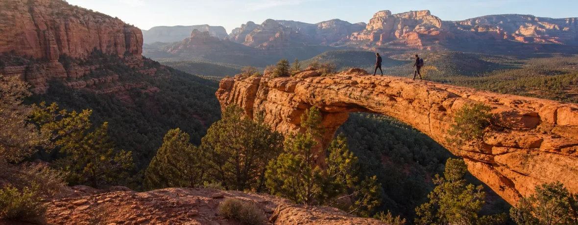
How long is Devils Bridge hike? The hike is 3.9 miles (6.3 km) round trip from Dry Creek Vista via FR 152, 4 miles (6.4 km) from Mescal Trailhead, 5.7 miles (9.2 km) via Chuckwagon, or 1.6 miles (2.6 km) from the 4×4 Devil’s Bridge Trailhead.
Devil’s Bridge is the Sedona hike everyone has seen in photos: the red sandstone arch, the skinny-looking span, the wide desert backdrop. The route is not just one route, though. Your distance depends on where you start, what you drive, and whether you want the shortest walk, the prettiest approach, or the least road walking.
How long is Devils Bridge hike from each trailhead?
The shortest normal hiking answer is 3.9 miles (6.3 km) round trip from Dry Creek Vista via FR 152 and Devil’s Bridge Trail.
That number comes with a catch. The named Devil’s Bridge Trail itself is only 0.8 miles (1.3 km) one way, with 350 feet (107 m) of elevation change, according to the Coconino National Forest Red Rock Recreation Guide. Most hikers cannot or should not drive to that trailhead in a regular car, so they add an approach from Dry Creek Vista, Mescal, or Chuckwagon. As of November 2026, Sedona Shuttle lists 3.9 miles (6.3 km) round trip from Dry Creek Vista via FR 152, 4 miles (6.4 km) from Mescal Trailhead, and 5.7 miles (9.2 km) via Chuckwagon. (fs.usda.gov)
| Starting point | Round-trip distance | Best for | Main tradeoff |
|---|---|---|---|
| Devil’s Bridge 4×4 Trailhead | 1.6 miles (2.6 km) | High-clearance 4×4 users | Rough access road |
| Dry Creek Vista via FR 152 | 3.9 miles (6.3 km) | Shortest regular hiking route | Dirt road walking |
| Mescal Trailhead | 4 miles (6.4 km) | Better trail feel | More junctions |
| Dry Creek Vista via Chuckwagon | 5.7 miles (9.2 km) | Scenery and less road | Longest common route |
Which Devil’s Bridge route should you take?
Take Mescal if you want the best balance of distance, scenery, and avoiding the access-road trudge.
The Mescal route starts from Mescal Trailhead, follows Mescal Trail toward Chuckwagon, joins Chuckwagon, then turns onto Devil’s Bridge Trail for the final climb. It is only 0.1 mile (0.2 km) longer than the Dry Creek Vista road route, but it feels much more like a Sedona hike: red dirt, juniper, cactus, open rock views, and less time sharing space with off-road vehicles.
Take Dry Creek Vista via FR 152 if you want the simplest line. You park or get dropped at Dry Creek Vista, walk the dirt road to the signed Devil’s Bridge Trail, then climb to the arch. This is easy to follow, but dusty, exposed, and less inspiring for the first half.
Take Chuckwagon if you came to hike, not just collect the bridge photo. At 5.7 miles (9.2 km), it adds real distance, but the walking is more enjoyable. You trade speed for curves, views, and a calmer approach before joining the final tourist stream.
Use the 4×4 trailhead only if your vehicle is made for rough roads and you know how to drive them. A rental sedan is not the move. The access road is the part that catches people out, not the final trail.
Is Devil’s Bridge hike hard?
Devil’s Bridge is moderate, not brutal, but the final climb makes it feel harder than the mileage suggests.
The early portion depends on your route. FR 152 is a dirt road walk with gradual grade. Mescal and Chuckwagon are real trail miles with rolling terrain. The named Devil’s Bridge Trail is where the hike changes character: it gets rockier, steeper, and more crowded as you climb toward the arch.
Near the top, expect stone steps, uneven sandstone, loose grit, and short sections where you will use your hands for balance. This is not technical climbing. You do not need ropes. You do need shoes with grip and the sense to slow down when people are coming the other way.
The bridge itself is wider than it looks in many photos, but the drop is real. If heights make your legs buzz, you can still enjoy the view without walking onto the span. No photo is worth wobbly knees and bad decisions.
Where do you park for Devil’s Bridge?
Most hikers park at Dry Creek Vista or Mescal Trailhead, or use the free Sedona Shuttle when it is running.
Dry Creek Vista is the classic parking area for the shorter road approach. Mescal Trailhead is the better pick for hikers who want a trail approach with only a tiny distance penalty. Both can fill early during spring, fall, weekends, and holiday periods. If you are aiming for a sunrise start, arrive before the easy parking window disappears.
As of November 2026, Sedona Shuttle Route 11 serves Dry Creek Vista and Mescal from the West SR 89A Park & Ride. The trailhead shuttle normally runs Thursday through Sunday, 7:00 AM to 5:30 PM, with expanded service during select peak periods; the shuttle site says no reservations are needed. Check the Sedona Shuttle Route 11 schedule before you build your day around it. (sedonashuttle.com)
Shuttle riders do not pay a trailhead parking fee, because they are not parking at the trailhead. As of November 2026, Sedona Shuttle states that both Park & Ride parking and trailhead shuttle rides are free. (sedonashuttle.com)
Do you need a pass or permit for Devil’s Bridge?
You do not need a hiking permit for Devil’s Bridge, but you need a recreation pass if you leave a vehicle at a Forest Service fee site.
As of November 2026, the Forest Service guide says that if you leave your vehicle while recreating at one of the Red Rock fee sites, you must display either a Red Rock Pass or a Federal Recreation Lands Pass. The same guide lists Red Rock Pass prices as $5 daily, $15 weekly, and $20 annual, and says the passes are not transferable between vehicles. Check the official Forest Service recreation guide before your trip, because fee rules can change. (fs.usda.gov)
A pass is for parking, not for standing on Devil’s Bridge. If you arrive by shuttle, bike, or on foot from a place where you are legally parked without a Forest Service fee requirement, the pass question changes. The cleanest move is simple: if you park at Dry Creek Vista or Mescal, display the required pass.
What is the best time to hike Devil’s Bridge?
Start at sunrise for cooler temperatures, easier parking, softer light, and a shorter wait at the bridge.
Devil’s Bridge is popular enough that “early” has a strict meaning. In peak season, a 9:00 AM start can already feel late. By midmorning, the final climb may have a line of hikers waiting for bridge photos, and the return can feel hot and dusty.
Spring and fall bring the friendliest hiking weather, but they also bring the biggest crowds. Winter can be excellent, with crisp air and lower traffic, though icy patches can form after storms. Summer is the serious one. Sedona heat can turn a moderate hike into a punishing slog, especially on the exposed road sections and pale sandstone near the arch.
If you hike later in the day, build your plan backward from sunset. The final descent has rock steps and loose footing. You want daylight for that. Carry a headlamp anyway. Phone flashlights are weak, awkward, and battery-hungry.
How do you hike Devil’s Bridge from Dry Creek Vista step by step?
The Dry Creek Vista route is the simplest to follow: walk FR 152 to Devil’s Bridge Trail, climb to the arch, then return the same way.
- Start at Dry Creek Vista Trailhead. Use the restroom if available, check your water, and confirm you have your pass displayed if you parked there.
- Walk FR 152, the dirt access road. Stay alert for Jeeps, OHVs, bikes, and dust.
- Continue to the signed Devil’s Bridge Trail junction. Do not turn onto random social paths.
- Take Devil’s Bridge Trail uphill. The trail narrows and gets rockier as it climbs.
- Climb the natural stone steps near the top. Let faster hikers pass in safe spots.
- Reach the main viewpoint below and beside the arch. This is the best place to pause before the photo area.
- If you choose to walk onto the bridge, wait your turn, move calmly, and keep both hands free.
- Return the same way. Watch your footing on the descent; loose grit on sandstone can slide like ball bearings.
What should you pack for Devil’s Bridge?
Pack for sun, slickrock, crowds, and a longer day than the mileage suggests.
This is not a deep wilderness expedition, but it is still desert hiking. People get into trouble here because the hike looks short on a map, then the sun, photo line, and return walk add up.
- Water: carry more than you think you will drink, especially from late spring through early fall.
- Salty snacks: useful when heat and sweat start draining your energy.
- Sun protection: hat, sunglasses, sunscreen, and light long sleeves.
- Footwear: trail shoes or hiking shoes with real grip.
- Navigation: downloaded map or paper map; do not rely on perfect cell service.
- Headlamp: small, light, and useful if your timing slips.
- First-aid basics: blister care, bandage, and any personal medical items you normally need.
- Trash bag: pack out peels, wrappers, tissues, and dog waste.
Can dogs hike Devil’s Bridge?
Dogs can do the hike if they are fit, leashed, heat-safe, and comfortable around crowds.
The biggest issue is not the mileage. It is the surface and the heat. Red rock and dirt can burn paws, and the final climb has steps and congestion. A nervous dog on a narrow rock section is stressful for everyone.
If you bring a dog, start early, carry water for the dog, and turn around if the ground is too hot for your bare hand. Do not let your dog walk onto the bridge if it is scared, pulling, or crowding other hikers. That photo is optional. Your dog’s safety is not.
When to see a doctor
Get medical help fast if heat symptoms worsen, last longer than one hour, or include confusion, fainting, seizure, or inability to drink.
Desert hikes can trigger heat illness even on routes that look moderate. The CDC lists headache, nausea, dizziness, weakness, thirst, heavy sweating, elevated body temperature, and decreased urine output among heat exhaustion symptoms. Mayo Clinic advises contacting a healthcare professional if heat exhaustion symptoms get worse or do not improve within one hour, and seeking immediate help for confusion, loss of consciousness, inability to drink, or a core temperature of 104°F (40°C). Read the CDC heat-related illness guidance and Mayo Clinic heat exhaustion guidance before hiking in hot weather. (cdc.gov)
Call 911 if you suspect heatstroke. Move the person out of the heat, start cooling them, and do not wait for symptoms to “settle down” if mental status changes show up. This is trail safety, not toughness.
Related reading
- How Long Is the Appalachian Trail? Miles, States and Time
- How to Plan a Camping Trip
- Where Does the Appalachian Trail Start and End?
- How to Start Camping: A Beginner's Guide
FAQ
How long does Devil’s Bridge hike take?
Plan on 2 to 3 hours for most routes. Add more time if you take Chuckwagon, hike in heat, stop often for photos, or wait in line to walk onto the bridge.
What is the shortest Devil’s Bridge hike?
The shortest hike is 1.6 miles (2.6 km) round trip from the Devil’s Bridge 4×4 Trailhead. For regular hikers without a high-clearance 4×4, the shortest common route is 3.9 miles (6.3 km) round trip from Dry Creek Vista via FR 152.
Is Devil’s Bridge scary?
It can be scary if you dislike heights. You can enjoy the arch from the viewpoint without walking onto the bridge, and that is the smarter choice if you feel shaky or crowded.
Is Devil’s Bridge worth it?
Yes, if you start early and pick the right route for your style. If you hate crowds, take the Chuckwagon approach or go at a quieter time of year instead of chasing the fastest route.
Can you hike Devil’s Bridge without the shuttle?
Yes. You can drive to Dry Creek Vista or Mescal Trailhead and hike from there, but parking can fill early and a recreation pass may be required. The shuttle is a strong option when schedules line up.
Do you need a 4×4 for Devil’s Bridge?
You need a capable high-clearance 4×4 only if you want to drive all the way to the Devil’s Bridge Trailhead. You do not need one for the standard hiking routes from Dry Creek Vista or Mescal Trailhead.