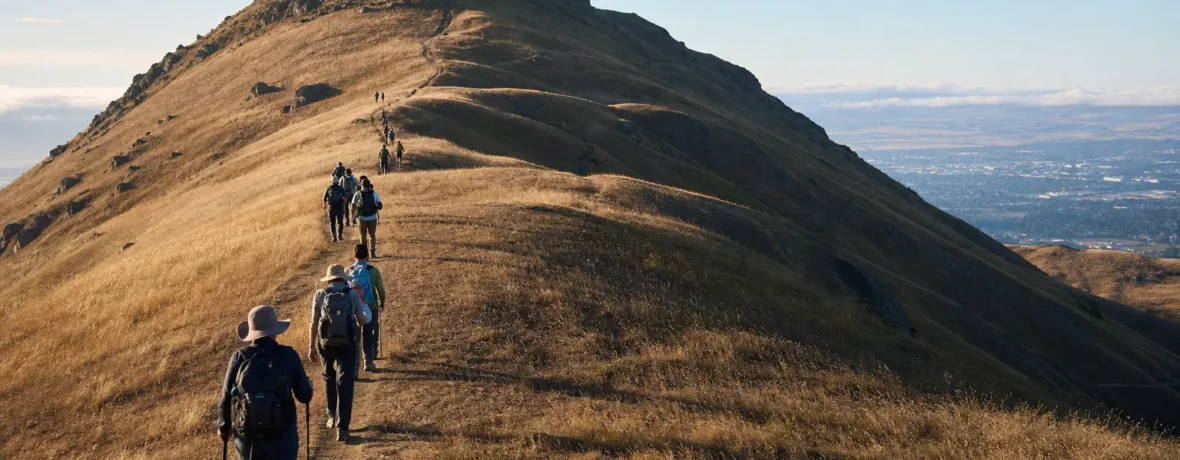
The Mission Peak hike is 6 to 7 miles round trip [9.7 to 11.3 km] for the standard summit hike. Start at Stanford Avenue for the shortest, steeper route, or Ohlone College for a slightly longer, more gradual climb.
How many miles is Mission Peak hike from each trailhead?
Mission Peak is a 6 to 7-mile round-trip hike [9.7 to 11.3 km], depending on where you start.
The classic Fremont summit hike climbs from the west side of Mission Peak Regional Preserve to the summit marker at 2,517 feet [767 m]. The East Bay Regional Park District describes the hike as a “3-plus-mile” climb each way and says most hikers should plan on a 5-hour round trip. Check the official Mission Peak Regional Preserve page before you go, especially for hours, parking, alerts, and seasonal rules.
| Start point | Round-trip distance | Best for | Tradeoff |
|---|---|---|---|
| Stanford Avenue Staging Area | 6 to 6.5 miles [9.7 to 10.5 km] | Shortest summit route | Steeper climb, tight parking |
| Ohlone College | 6.8 to 7.5 miles [10.9 to 12.1 km] | Easier parking and steadier grade | Slightly longer walk |
| Sunol / Ohlone Wilderness side | Much longer point-to-point options | Backpacking or big-mile days | Not the standard day-hike route |
If you only want the famous summit post, stay with Stanford Avenue or Ohlone College. The Sunol approach belongs in a different plan: longer, more committing, and tied into the Ohlone Wilderness Trail.
What is the Mission Peak elevation gain?
Expect roughly 2,100 feet [640 m] of climbing on the standard Mission Peak summit hike.
That is the number that catches people. Six miles sounds friendly. Two thousand feet of open, sun-blasted climbing does not. Mission Peak rises fast from Fremont, and the trail gives you very few flat sections where your calves can call a timeout.
The summit is marked on the official park map at 2,517 feet [767 m]. The climb starts low on the Fremont side, so most of the summit’s height gets packed into the hike. The official Mission Peak map and brochure also shows the trail network, contour lines, trail posts, restroom icons, and the two main Fremont-side access points.
How hard is Mission Peak hike?
Mission Peak is a hard day hike, not a casual hill walk.
The difficulty comes from three things: sustained grade, sun exposure, and popularity. You climb for miles. Then you descend those same miles on tired legs. On a cool morning, strong hikers move well here. On a hot afternoon, the same trail can feel punishing.
Here is the honest rating:
- Distance: moderate, at 6 to 7 miles [9.7 to 11.3 km] round trip.
- Elevation gain: hard, near 2,100 feet [640 m].
- Shade: limited, especially on the exposed upper slopes.
- Trail surface: mostly dirt road and trail, with steeper, rockier sections near the top.
- Navigation: straightforward if you stay on signed trails and carry the map.
If you hike weekly and have done 1,500-foot [457 m] climbs, Mission Peak is a strong but reasonable step up. If your recent hiking has been flat neighborhood walks, train first. Your knees will thank you on the descent.
Where do you park for Mission Peak?
Park at Ohlone College if you want the least stressful Mission Peak parking plan.
As of November 2026, East Bay Regional Park District strongly encourages hikers to access Mission Peak from Ohlone College because Stanford Avenue gets heavily congested on weekends and holidays. Ohlone College access is at 43600 Mission Blvd. in Fremont, with parking in designated campus lots and the parking structure. The district states that Ohlone College charges a $4 parking fee, and that vending machines take cash or credit cards; confirm current details on the linked Ohlone parking information from the official park page before driving.
Stanford Avenue is the famous trailhead, but the small lot fills fast. As of November 2026, the surrounding Mission Peak neighborhood has weekend, holiday, and observed-holiday parking restrictions. Do not assume you can circle the neighborhood and find a legal spot. That is how hikes start badly.
Use this parking plan:
- Choose Ohlone College for weekends. It has more capacity and a more forgiving start.
- Use Stanford Avenue on non-holiday weekdays. Go early and read every posted sign.
- Do not park overnight at Ohlone College. Overnight parking is not allowed there as of November 2026.
- Do not try Mill Creek Road. The park district states there is no public access to Mission Peak from Mill Creek Road.
- Have a backup. If the lot is full, switch trailheads, rideshare, bike, or pick another Fremont-area hike.
Which is better: Stanford Avenue or Ohlone College?
Ohlone College is better for most first-time Mission Peak hikers.
Stanford Avenue wins if you want the shortest route and do not mind a steeper grind. Ohlone College wins if you want easier parking, a steadier climb, and a less chaotic start. The park district calls the Ohlone route slightly longer but more gradual, which is exactly the trade you want when the weather is warm or your group has mixed fitness.
| Question | Stanford Avenue | Ohlone College |
|---|---|---|
| Shortest route? | Yes | No |
| Easiest parking? | No | Yes |
| More gradual climb? | No | Yes |
| Best first visit? | Only if you start early | Usually yes |
How long does it take to hike Mission Peak?
Plan 4 to 5 hours for the full Mission Peak hike.
Fast hikers can finish sooner, but do not build your day around a speed run unless you already know your pace on steep Bay Area climbs. The official park guidance says 5 hours are required to reach the summit and return. That number is smart for first-timers, groups, warm days, and anyone stopping for photos at the summit post.
A practical pacing plan looks like this:
- Start to halfway up: 45 to 75 minutes.
- Halfway to summit: 60 to 90 minutes.
- Summit break: 10 to 25 minutes, depending on wind and crowds.
- Descent: 75 to 120 minutes.
Start early. Not dramatic. Just smart. The trail has limited shade, and heat bakes the open slopes long before the day hits its high temperature.
What should you bring for Mission Peak?
Bring more water than you think you need.
The official park brochure says no drinking water is available along the trails and recommends 2 liters per person. That is the minimum for many hikers, not a trophy for packing light. If it is hot, if you run warm, or if you are bringing a dog, carry extra.
Pack this:
- 2 liters of water per person minimum [67.6 fl oz]
- Extra water for dogs
- Sun hat and sunglasses
- Sunscreen you will reapply
- Salty snack or lunch
- Trail shoes or hiking shoes with grip
- Wind layer for the summit
- Downloaded map or paper map
- Phone battery reserve
- Trash bag for wrappers and dog waste
Skip sandals. Skip “I’ll just carry one small bottle.” Skip late starts in summer heat. Mission Peak is short enough to tempt bad decisions and steep enough to punish them.
Is Mission Peak dog friendly?
Yes, dogs are allowed, but Mission Peak can be rough on dogs in warm weather.
As of November 2026, the official park brochure says dogs must be leashed in parking lots and within 200 feet [61 m] of trailheads and developed areas. On trail, follow posted rules and keep control around other hikers, horses, bikes, cattle, and wildlife.
The bigger issue is heat. East Bay Regional Park District warns that dogs have died from heat stroke and dehydration at Mission Peak. If the forecast is warm, leave your dog home. They do not care about the summit selfie. They care about shade, water, and not burning their paws on hot ground.
For dogs, bring:
- A leash
- A collapsible bowl
- More water than you expect to use
- Waste bags
- A plan to turn around if your dog slows, pants heavily, or looks unfocused
When is the best time to hike Mission Peak?
The best time to hike Mission Peak is early morning on a cool, clear weekday.
Spring brings green hills and wildflowers. Winter can deliver crisp air and big views after storms. Fall is often pleasant if you avoid hot spells. Summer can be harsh because the route is exposed and shade is limited.
As of November 2026, Ohlone College Entrance hours are 6 a.m. to 10 p.m. daily, year-round. Stanford Avenue has seasonal hours for the yellow section shown on the park map: 6:30 a.m. to 8 p.m. from December 23 through March 31, and 6:30 a.m. to 9 p.m. from April 1 through December 22. The remaining green areas on the map are open 6 a.m. to 10 p.m. Hours are enforced, so check the official park page before sunrise or sunset plans.
How do you hike Mission Peak step by step?
Pick your trailhead, climb steadily, stay on signed trails, and save energy for the descent.
- Check the official park page. Look for alerts, closures, hours, and parking updates.
- Start early. Beat heat and parking pressure in one move.
- Use the restroom at the trailhead. Do not count on facilities higher up.
- Set a turnaround time. If you are not near the summit by then, turn around without drama.
- Climb at a pace you can hold. If you are gasping in the first mile, slow down.
- Stay on the official trail. Shortcuts damage the hillside and can earn enforcement attention.
- Take your summit photo, then move aside. The summit post gets crowded.
- Descend carefully. Loose dirt and tired quads make slips more likely on the way down.
When to see a doctor
Get medical help right away if heat symptoms worsen, vomiting starts, confusion appears, or symptoms do not improve after cooling and rest.
Heat illness is the health concern that matters most on Mission Peak. The CDC heat guidance lists warning signs such as heavy sweating, weakness, dizziness, nausea, headache, confusion, and fainting. Heat stroke is a medical emergency; call 911 if someone is confused, loses consciousness, has a very high body temperature, or has hot, red, dry or damp skin.
Do not try to diagnose yourself on the trail. Stop, move to shade or a cooler place, cool the body, sip water if alert and able, and get help if symptoms are severe or not improving. If you have heart disease, take medications that affect fluid balance, are older, are pregnant, or have a history of heat illness, talk with a clinician before hiking in hot conditions.
Related reading
- How Many Miles Should You Walk a Day?
- How Many Days Do You Need in Glacier National Park?
- How Long Does It Take to Hike 10 Miles?
- How Long Does It Take to Hike Pikes Peak?
FAQ
How many miles is Mission Peak hike round trip?
Mission Peak is 6 to 7 miles round trip [9.7 to 11.3 km] for the usual Fremont summit routes. Stanford Avenue is the shorter, steeper choice; Ohlone College is slightly longer and more gradual.
How much elevation gain is Mission Peak?
Mission Peak gains roughly 2,100 feet [640 m] from the Fremont-side trailheads. The summit is marked at 2,517 feet [767 m] on the official park map.
Is Mission Peak good for beginners?
Mission Peak is not the best first hike for a true beginner. It is fine for a fit beginner who starts early, brings enough water, and is ready to turn around before the summit if heat or fatigue kicks in.
Do you need a permit to hike Mission Peak?
You do not need a day-hiking permit for the standard Mission Peak summit hike from Stanford Avenue or Ohlone College. Permits and reservations may apply for backpacking or Ohlone Wilderness Trail plans, so check the official East Bay Regional Park District pages before anything beyond a day hike.
Can you hike Mission Peak at sunset?
Yes, but only if you can finish within posted park hours. As of November 2026, hours vary by entrance and season, and the park district says citations may be issued after closing.
Is there water on the Mission Peak trail?
No drinking water is available along the trails, according to the official park brochure. Carry at least 2 liters per person [67.6 fl oz], and bring extra for dogs or hot conditions.